Posts

Video repository launched

Image
My own drone footage video repository related to river hydraulics is already available at YouTube It is thought to promote Capacity Building or educational courses on Flood Risk Mitigation and Modelling , assisted by drone monitoring and image postprocessing , including: How to measure flow discharge and current patterns by means of non intrusive optical processing.  Observe geomorphological river patterns in real time and scale: erosion and deposition regions linked to surface currents. Identify Nature Based Solutions like flood bypasses and spill basins affecting hydraulic capacity and routing. Introduce numerical modelling for simple cases with the Set Up of 1D & 2D Shallow Water Equations models.  Finding of proper survey locations when the waters run high. And why not ! admire and get inspired directly by nature.  A short guide about how to interpret the videos is published in the FREE DELTA section .  
First year hits

Image
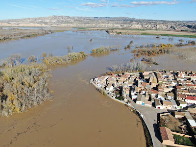
This site is one year old. Highlights are the visits by country shown in the bottom picture, and an interesting flood dynamics video filmed at  Cabañas de Ebro   to be observed carefully and compared with the dry period image posted in August.

Investing in Nature ?

Image
New ways of funding and concepts: natural capital, blended and scaled financial packages, revenue streams, etc., moreover 19 nature-based solutions across Europe, already presented at EIP Water conference, Zaragoza, 2019. Download link:  Trémolet S. et al. (2019). Investing in Nature for Europe Water Security. The Nature Conservancy, Ecologic Institute and ICLEI. London, United Kingdom.

Nothing like this planet, preserve it

Image
Ebro river marshes at Alfaro, La Rioja, Spain. In support of COP25@Madrid

Summer surveys

Image
Summer is a good time to fly over flood prone scenarios while keeping low waters  and record flow patterns, state of embankments, blocking vegetation  and alleviation paths, as seen for Cabañas de Ebro (Saragosse, top image), Ter river (Barcelona) and Escalona (Pyrenees), that will be reported in  riverdrone or elsewhere.

Satellite images applied to estimate soil water content:

Image
Last week the other lecturer at the 5 days intensive course on Statistics for Hydrology and Telemetry , at CENPAT Port Madryn, Argentina, Dr. Mauro E. Holzman from IHLLA institute, taught us how to estimate the soil water content by means of the MODIS/Aqua satellite images. A QGIS processed vegetation index image is shown for part of Buenos Aires province: "Las Pampas". The surface temperature and reflectance bands allow to estimate the EVI index, and furthermore the soil moisture content and rates of evapotranspiration . Deeper insight at: https://doi.org/10.1016/j.isprsjprs.2018.03.014

April in Argentina:

Image
This time visiting again IHLLA institute at Azul, the National University of Patagonia San Juan Bosco, Puerto Madryn, and possibly the UTN at Concordia. The upgraded map of stays during the last couple of years is shown. Activities will be reported soon ...